Open Space Planning
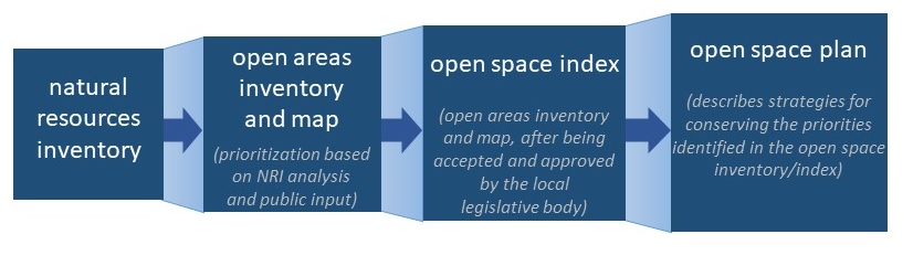
With a natural resources inventory (NRI) in hand, communities are well-positioned to develop strategies to conserve their priority natural areas and the many benefits that come with a healthy environment. Combined with analysis and community input, the NRI provides a foundation for developing an open space inventory and plan.
What is open space?
The term open space refers to land that is not intensively developed for residential, commercial, industrial, or institutional use. Open space serves many purposes, whether publicly or privately owned, and can include parks, recreational sites, scenery, trails, forests and woodlands, wetland and stream corridors, rare or important habitats, farms, and historic properties.
Open Space Inventory and Index
Terminology used in local open space planning in New York originates from NYS General Municipal Law Sections 239-x and 239-y, which direct Conservation Advisory Councils (CACs) to create an open areas inventory and map. Different terms are sometimes used by municipalities, but the purpose of an open areas inventory is the same--to identify open spaces with conservation, historical, or scenic significance, and list them in priority order for acquisition or preservation. Once the inventory and map are approved by the local legislative body, they become the municipality's open space index. The CAC can then become a conservation board and more formally participate in land use reviews affecting areas in the index.
Definitions from NYS General Municipal Law Section 239-y
open area: any area characterized by natural scenic beauty or, whose existing openness, natural condition, or present state of use, if preserved, would enhance the present or potential value of abutting or surrounding development or would establish a desirable pattern of development or would offer substantial conformance with the planning objectives of the municipality or would maintain or enhance the conservation of natural or scenic resources.
conservation open areas inventory: an inventory of open areas within the municipality with each such area identified, described, and listed according to the priority of acquisition or preservation.
conservation open areas map: a map or maps identifying open areas within the municipality which are earmarked for preservation, including, but not limited to, open areas that are required to be set aside out of subdivision plats, publicly owned open areas, open areas preserved by nonpublic organizations, and open areas having conservation, historical, or scenic significance.
open space index: the conservation open areas inventory and conservation open areas map after acceptance and approval by the local legislative body.
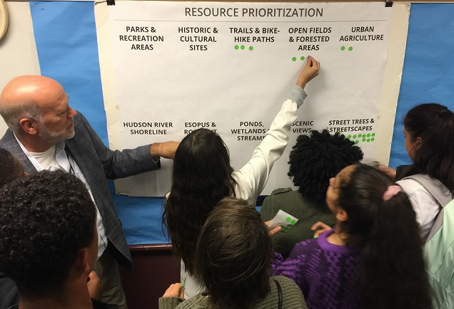
How do municipalities determine their conservation priorities? While not a requirement, the development of an NRI is recommended as the basis for the open areas inventory. Often, an NRI and open areas prioritization are folded into the process of developing an open space plan. Whichever the approach, it's also important to gather input from residents on the resources they care about. This might take the form of interactive public meetings, mailed surveys, online polls, photo submissions, or a combination of different techniques. Map analysis using Geographic Information Systems (GIS) can help to identify priority areas, by looking for high-quality or co-occurring resources that meet multiple community interests, such as aquifer recharge, scenic beauty, unfragmented forest, and wetland habitat.
Open Space Inventory and Index in Practice
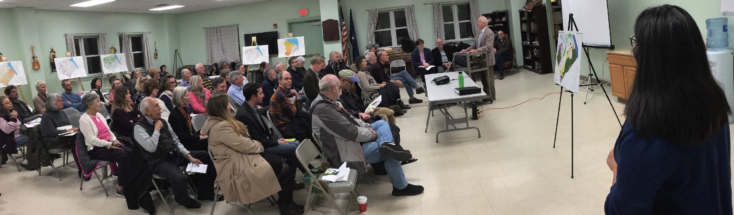
The Towns of Blooming Grove and Cornwall, and the Village of Cornwall-on-Hudson (Orange County) worked together as an intermunicipal team to create their open space inventories (OSIs). To gather input on residents' conservation priorities, the team held public workshops and distributed surveys. This community input and the data from their natural resource inventories helped the towns identify clusters of specific parcels that were most important for local conservation. The Cornwall OSI (2019) is available here. The Town of Blooming Grove used its OSI to create a community preservation plan (2020) – a first step in establishing a community preservation fund to finance open space conservation in the town.
The Town of Philipstown's (Putnam County) open space index was adopted in 2009 and amended in 2016. The recent version includes an updated map and summaries of the 27 conservation open areas identified in the index.
Open Space Plans
Once priorities are identified, mapped, and described, an open space plan outlines the best options for use and protection of those priorities, and lays out a plan for action with clear recommendations. Acquisition is only one mechanism for meeting open space goals; examples of other approaches include zoning updates, designation of critical environmental areas, revegetating stream and wetland buffers, and connecting recreational trails. For communities pursuing conservation financing through a Community Preservation Fund, a community preservation project (CPP) plan must be adopted. The CPP plan is similar to an open space plan, but has specific content and process requirements outlined in NYS General Municipal Law Section 6-s.

The value of open space is greater when it's considered in the context of the overall environment, rather than viewed in isolation. For example, open space plans provide opportunity to devise intermunicipal strategies for prominent features that require coordinated conservation efforts by multiple communities, such as large forests and watersheds. In addition, relating new open space protection priorities to existing protected lands is encouraged. Conservation principles can be considered and incorporated into the plan.
From a conservation standpoint, it's important that local open space plans:
- are based on accurate information and maps, and substantial community input
- are developed in a format that is useful to the community for conservation and land-use planning, and able to be updated periodically
- take a "big picture" view of the community and how it relates to surrounding ecosystems, watersheds, and conserved lands
- provide clear recommendations and actionable steps to help the community reach meaningful conservation outcomes.
Open Space Plans in Practice
The City of Kingston (Ulster County) used its NRI (2018) as a foundation to develop an open space plan in 2019 that includes specific and ambitious conservation targets, including 1,000 new street trees; 5,000 linear feet of new public access to the Hudson River; and more than 600 acres of newly protected land. In 2020, the city adopted the open space plan as an addendum to its comprehensive plan.
The Town of Poughkeepsie (Dutchess County) undertook a joint Natural Resources Inventory and Open Space Plan development process with funding from an Estuary Grant. The Open Space Plan created a GIS-based Conservation Analysis Tool and identified key opportunity areas for potential acquisition or connections.
The rural towns of Rochester and Wawarsing (Ulster County) recognized they shared more than a border; they also shared natural features like the Rondout Creek and large, connected forests. They worked together on the open space planning process, developing both common and individual priorities and recommendations. The results are included in the Town of Rochester Natural Heritage Plan (2018) and the Town of Wawarsing Open Space Plan (2018).
The Rensselaer Land Trust developed a Rensselaer County Conservation Plan (2018) to prioritize where the land trust and partners will proactively pursue conservation to have the most positive impact on the county's natural resources, landscapes, and quality of life. An interactive story map provides a web-based opportunity to view the findings of the plan. In addition to taking a county-wide view, the plan lists conservation priority areas in each municipality.
Adopting and Implementing an Open Space Inventory, Index, or Plan
The open space inventory, index, or plan is complete; what's next? To support conservation planning efforts by municipalities, we worked with long-time partner Pace Land Use Law Center to develop legal guidance and best practices for adopting and implementing NRIs, open space inventories and plans, and CEAs. Best Practices for Adopting Conservation Inventories and Plans: A Guide for Communities in the Hudson River Estuary Watershed explores three options for municipalities that are ready to take the "next steps"—policy statements in resolutions, comprehensive plans, and local laws—and offers procedural guidance and many examples from Hudson Valley communities.
Helpful Links
Recorded webinar about Open Space Inventories and Plans from 2021 (Part of the Conservation and Land Use webinar series)
Local Open Space Planning Guide (NYS Department of State and DEC 2004)
Conserving Natural Areas and Wildlife in Your Community (Strong 2008)
Economic Benefits of Open Space Protection (Office of the New York State Comptroller 2010)